


Hurricane Ida strengthens; expected to make landfall Sunday
By ALAN SMASON
Tropical Storm Ida quickly became Hurricane Ida on Friday with maximum force winds of 80 miles per hour, establishing it as a Category 1 storm. Weather forecasters anticipate the storm will continue to strengthen and will likely become a monster Category 4 Storm with winds estimated to be at 140 miles per hour at landfall near Houma on Sunday morning.

Hurricane Ida, a Category 1 storm, pummels Cuba with rain bands extending up to the Florida peninsula on Friday. The storm is expected to hit New Orleans on Sun., Aug. 29, the 16th anniversary of Hurricane Katrina.
The warm waters of the Gulf of Mexico are expected to help the further intensification of the hurricane increasing the deadly storm surge predictions from 10 to 15 feet along the Southeast Louisiana coast. Storm surge estimates on the North Shore of Lake Pontchartrain range from 7 to 11 feet.
Louisiana Governor John Bel Edwards declared a state of emergency on Friday afternoon prior to the storm’s impact on the Louisiana shoreline. President Joe Biden issued a federal emergency declaration following consultation with Edwards. This will help the state and city receive federal aid much more promptly once the storm has passed.
All state and local parish offices are expected to remain closed from Friday through Monday. Most area businesses are also expected to close on Saturday.
Edwards also announced the cancellation of the Saints versus Arizona Cardinals preseason NFL game originally slated to be played on Saturday night and then moved up to 12 noon.
On Friday evening, Hurricane Ida continued to move due northwest at 15 miles per hour with winds of 80 miles per hour. The central measured pressure was 985 millibars of mercury. The relatively fast-moving storm will feed off the warm Gulf waters and intensify from a Category 1 storm into a Category 2 and, later, a Category 3 storm late on Saturday. It is projected to be a Category 4 storm when it makes landfall on Sunday near Houma or westward at Vermillion Bay with 140 mile-per-hour winds. By the time it hits New Orleans, winds are estimated to be at least 110 m.p.h.
These dangerous winds will cause probable power failures across a wide swath of South Central and Southeast Louisiana including all of New Orleans and the West Bank. Entergy crews will be dispatched once the winds subside to a safe level, below 5 miles per hour.
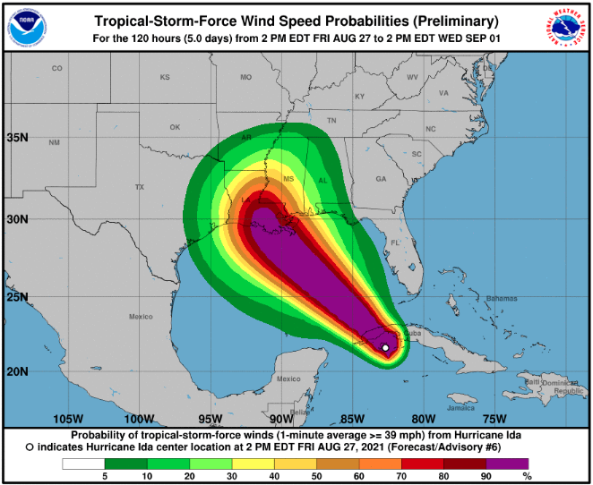
National Hurricane Center predictions for the path of Hurricane Ida
Mandatory evacuations have been called for Grand Isle and all unprotected areas of Jefferson Parish and in the unprotected areas of Plaquemines Parish including Belle Chasse. Orleans Parish also issued a voluntary evacuation for areas not protected by levees such as in New Orleans East and for everyone who does not feel comfortable in staying.
Mayor LaToya Cantrell explained to a press conference that preparations for the storm caught her administration too late to deal with a “contra-flow” mandatory exodus from the city. Otherwise, she would have issued a mandatory evacuation order, she said.
Sunday, August 29, is the 16th anniversary of Hurricane Katrina, still one of the most destructive and the costliest storm to ever hit the United States, and is also the 9th anniversary of Hurricane Issac that also passed through the New Orleans area with more limited damage, mostly due to heavy rains.
Hurricane Ida’s precise path will become better known once it crosses the island nation of Cuba and finishes battering the Caribbean island of Jamaica as well. However, all of the major forecast models call for the storm to better organize and make landfall in Southeast or South Central Louisiana.
The other problem compounding the oncoming storm is the large amount of rain that has preceded it this last week including heavy rains expected to continue throughout Friday and into Saturday. The ground will be super-soaked and the runoff will increase and add to concerns about probable flash flooding amounts expected to accompany the deadly storm
Currently, hurricane force winds extend outward for 20 miles from the center of the circulation, while tropical force winds extend 90 miles from the center.
Editor’s note: The CCJN will honor the sanctity of Shabbat and not send out updates throughout Friday night and on Saturday.
