
UPDATE: Hurricane Ida strengthens into massive Category 4 storm
By ALAN SMASON
Hurricane Ida continued to intensify late Saturday night in the open, warm waters of the Gulf of Mexico as forecasters declared it a dangerous major Category 4 storm early Sunday morning.
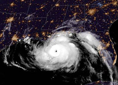
Hurricane Ida at 1:00 a.m. on Sun., Aug. 29. (NOAA)
Conditions remain favorable for further deepening of the storm with sustained winds of 150 miles per hour at landfall near Houma and Port Fouchon. The central pressure of the storm continued to drop to 933 millibars of mercury, another indicator that the storm was continuing to strengthen.
With sustained winds of 150 m.p.h. and gusts up to 185 m.p.h,, the center of Ida had become much more organized and was clearly defined on radar at 9:00 a.m CDT. It was located at 28.7 degrees longitude and 89.8 degrees latitude or about 40 miles south southeast of Grand Isle.
It is possible the hurricane could become the first Category 5 storm to ever hit Louisiana, eclipsing the record winds recorded by Hurricane Laura when it roared across Lake Charles last year. The most destructive storm, Hurricane Katrina, made landfall in 2005 in Mississippi.
Weather forecasters are predicting a deadly storm surge of between 12 and 16 feet at landfall in the River Parishes and at Grand Isle. A surge between 5 and 8 feet on the North Shore of Lake Pontchartrain and along the Mississippi Gulf Coast is also forecast.
In a press conference yesterday, Jefferson Parish president Cynthia Lee Sheng urged those living outside of the protective levee structure to flee immediately. “The storm surge we are expecting is unsurvivable,” she said.
Residents of the protected levee areas in Orleans and Jefferson Parishes are expected to endure 24 hours of continuous battering of heavy winds and torrential downpours. Street flooding can be expected along with rain amounts of 10 to 15 inches in some areas over the time of the storm’s passage.
Most of the New Orleans metropolitan area and adjacent parishes remain under a flood warning and a tornado watch until 7 p.m. Tornado watches and warnings are possible as the dangerous storm moves inland and the feeder bands spin off tornadoes. Entergy and CLECO officials have crews standing by as power outages are expected for customers for as much as two or three weeks.
Traffic delays of up to 12 or 13 hours in both east and west directions out of the city remained all day on Saturday. Texas officials reported heavy delays still outside of Beaumont on Sunday morning.
New Orleans city officials had asked for a voluntary rather than a mandatory evacuation due to the lack of time to prepare in advance by implementing contraflow on interstate highways leading outside of the city and other measures. Those unprotected areas of Orleans and Jefferson Parishes outside of levee protection have been under a mandatory evacuation notice since Friday.
